Noticias e investigación
Nuestros clientes avalan nuestra experiencia, entregamos soluciones de forma eficaz y eficiente a los requerimientos más exigentes. Somos un grupo de consultores multidisciplinares bolivianos con gran trayectoria en Chile y Estados Unidos para Bolivia
Instituciones y Normativas en las que respaldamos todos nuestros trabajos:


Noticias e investigaciones
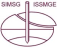
Geophysical mapping of aquifers in Bolivia
Electrical Resistivity Tomography (ERT) and Transient ElectroMagnetic sounding (TEM) is used for aquifer mapping in Bolivia.
Seismically-driven appraisal and development: A case study from Bolivia’s Chaco Basin
Through integration of multiple geophysical and geologic techniques, we significantly reduced the geotechnical risk associated with several prospects of Cretaceous reservoirs in an area of Bolivia’s Chaco Basin, and we verified our interpretations through the successful drilling of those prospects.
Using spectral decomposition to identify and characterize glacial valleys and fluvial channels within the Carboniferous section in Bolivia
The area of interest within Bolivia’s Santa Cruz Basin is covered by a 3D seismic survey that covers approximately 660 km2
Interpretation: Tomographic velocity analysis and wave-equation depth migration in an overthrust terrain: A case study from the Tuha Basin, China
Although the structures associated with overthrust terrains form important targets in many basins, accurately imaging remains challenging. Steep dips and strong lateral velocity variations associated with these complex structures require prestack depth migration instead of simpler time migration.
Interpretation: Seismic imaging in and around salt bodies
Seismic imaging of evaporite bodies is notoriously difficult due to the complex shapes of steeply dipping flanks, adjacent overburden strata, and the usually strong acoustic impedance and velocity contrasts at the sediment-evaporite interface.
Interpretation: Near-surface S-wave velocities estimated from traffic-induced Love waves using seismic interferometry with double beamforming
I use ambient noise, especially traffic noise, to estimate the 2D near-surface S-velocity distribution. Near-surface velocities are useful for understanding structure, stiffness, porosity, and pore pressure for engineering/environmental purposes and static correction of active-source imaging.
Artículos científicos y contenido Premium
Geophysical mapping of aquifers in Bolivia
Electrical Resistivity Tomography (ERT) and Transient ElectroMagnetic sounding (TEM) is used for aquifer mapping in Bolivia.
Seismically-driven appraisal and development: A case study from Bolivia’s Chaco Basin
Through integration of multiple geophysical and geologic techniques, we significantly reduced the geotechnical risk associated with several prospects of Cretaceous reservoirs in an area of Bolivia’s Chaco Basin, and we verified our interpretations through the successful drilling of those prospects.
¿Quiéres publicar un artículo en este portal? Contáctanos